(click on map to enlarge)

Ashigara Pass
I like to start my ride from Matsuda which has 2 train stations, one on the Odakyu Line and one on the JR Gotemba Line. From the station it’s a short trip down to Hwy 78 which crosses over the Sakagawa River and runs through the middle of town. The road turns right at the intersection just after the tunnel at the Ashigara Fire Station.
As it leaves town Hwy 78 gradually ascends alongside the Kari River down in the valley to the left. There are some beautiful farmlands with rice fields and mikan orchards. You can see the mountains of Hakone (Miyojingatake & Ashigara) off to the left.
At just over 12 km from Matsuda Station there is a turn off to the road that leads to Yuuhi Falls. It comes about a km after the turn off to Hwy 731 which goes to Hakone. The Falls are worth the detour. They have interesting folklore attached to them. They are said to be the birthplace of Kintaro, a folk hero from a Japanese legend.
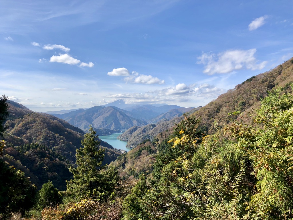
After the turn off to the falls Hwy 78 begins a steeper ascent up the side of the mountains leading up to Ashigara Pass. The road turns to switchbacks and offers a nice view looking back down the valley. At 759 meters Ashigara Pass is a respectable climb. At the top there is a grassy knoll overlooking the Gotemba Valley with a splendid view of Mt. Fuji on a clear day.
Coming down from the pass Hwy 78 turns into Hwy 365. It’s a nice swift descent passing through the Tomei Fuji Country club on its way down into the Ayuzawa River Valley. At the bottom you intersect Hwy 149 which runs parallel to Hwy 246 and the Tomei Expressway. I don’t like 246 as there are many large trucks barreling through there. I try to stay on the side roads when possible. You can follow this valley to Matsuda or beyond.
Ashigara Pass Gallery


Lake Tanzawa Matsuda Rindo
The Matsuda Rindo is a service road that runs from the Northeast end of Lake Tanzawa up over the mountains down into the city of Matsuda. The closest train station to Lake Tanzawa is Yaga Station on the JR Gotemba Line.
Hwy 76 runs along the Kouchi River and climbs for nearly 200 meters up to Lake Tanzawa. For the most part, the grades are easy making it an easy climb. Once up to the dam you turn right and ride along the south shore of the lake. This is a beautiful ride in the fall when the autumn leaves are in their colors.
At the end of the lake, just past Tanzawa Lodge, turn right on a small road that runs next to the small river. If you were to continue going straight on 710 you would be traveling along the Kurokawa River, which is famous for the Yuushin Hiking course. It is closed to bicycles but makes for a great cycling/hiking combo; especially in the autumn.
The service road crosses the river and begins to climb pretty quickly. Before long you are looking down on the river. On a clear day you are afforded a fantastic view of Mt. Fuji from there. There is a gate prohibiting cars there and the road becomes steeper and rougher as you climb. This tends to be a pretty secluded area with only a few hikers and public workers tending to the road.
Though the road is paved it can get pretty rough in places as its vulnerable to landslides. The big typhoon that hit in 2019 did serious damage to the road burying it in places and wiping out a bridge. As of this writing (1/2022), I’m not sure of its condition. It would be good to check before riding on it.
The grades hit double digits as the road rises to its highest point of 780 meters. The views are beautiful; especially up in the higher meadows. After coming over the top it descends for a bit and begins to climb again to the second peak of 742 meters and then descends all the way down to where it intersects the Nakatsu River. After going through the gate you come into a larger road open to car traffic. It follows the river down to the intersection of Rt 246, above Matsuda. The trip from Yaga to this point is 33 km.
Matsuda Rindo Gallery


Kiridoshi Pass
I originally discovered Kiridoshi Pass while riding my road bike up around Tanzawa Lake. I noticed Hwy 729 on the map and wanted to check it out. I found it to be much rougher than I had expected so I returned with my gravel bike to give it a try.
After going through the gate at the end of the lake the road quickly becomes rougher with some large rocks and gravel.
It’s a beautiful place for a gravel or mountain bike but you may not want to risk your road bike on it. It follows the Yozuku River back into the hills. It passes some waterfalls the second of which is called Odananotaki. If you go left at this point there is a very rough road that appears to climb up to Mikuni Pass (I’ve not yet traveled on it).
After traveling about 14 km (550 meters of climbing) from the lake the road ends there’s a faint hiking trail that goes up to Kiridoshi Pass. It’s about 100 meters of climbing carrying your bike. I did the trip from the opposite direction (from Yamakako) and found it’s only 50 meters of climbing from the road. At this point you are not far at all from Lake Yamanaka as the crow flies.
Kiridoshi Pass lies on the ridge above the grasslands next to Mikuni Pass. The trail runs along the ridge and allows you to peek through the trees at times. The trail heading down towards Yamanaka Lake is rough due to erosion from water runoff. Soon you come down to a nice paved road that intersects Hwy 730, the road coming down from Mikuni Pass. From there you come to Yamanaka Lake and have several choices on where to go.
Kiridoshi Pass Gallery


