East Kanagawa
(West Kanagawa Below)
(click on cyclist icon to see the route)

West Kanagawa

Tama River
(click on map to enlarge)

I have often seen the Tama River as being just a highway that gets me outside the city. But I have come to appreciate the beauty and the accessibility that it provides. It starts far back in the mountains of western Tokyo, running through Okutama down into the plain and forms the boundary between Tokyo and Kawasaki. There are bike paths on pretty much both sides of the river from Hamura on down to the ocean.
The paths can be a little narrow and are shared by runners and walkers so you need to be careful not to hit anyone. It’s a great place to observe people doing various activities as the flood plain serves as the playground for people in the city. There are many baseball and soccer fields and short pitch and put golf courses as well as spacious picnic areas. Even people practicing musical instruments.
There are several other rivers that empty into the Tama with bike paths of their own. My favorite is the Asa River, which drains into the Tama near Fuchu. You can ride along the path all the way to the Takao area. There is also the Aki River, which intersects it near Haijima. It flows from the mountains of Hinohara, one of my favorite places to ride. The Nogawa comes in at Futagotamagawa. You can follow it north and west through Tokyo.
One of my favorite times to ride the Tama is during the spring when the cherry trees are blossoming. There are lines of white blossoms on various points up the river. I like to ride from Kawasaki all the way up to Hamura, which has some of the best cherry blossoms. I’ll put a few photos of that ride in the photo gallery down below.
From Ome back into the mountains the Tama’s character changes into a pristine white-water stream that flows through the Okutama area. I have a separate page for Okutama here.
Tama River Gallery (click on photos to view)


Tsurumi River

Living very close to the Tsurumi River I've come to see it as my highway through Shin Yokohama out to Machida. It serves as the border between Kawasaki and Yokohama with some very wide smooth bike lanes; much wider than those on the Tama River. You can ride all the way from Kawasaki to Machida only having to stop at one traffic light in Shin Yokohama.
The road through Shin Yokohama on the north side of the river is especially wide and smooth as it looks as if it was made for cars. It runs under a huge viaduct constructed for the expressway running through there. There are some beautiful lines of cherry trees along the south side near Kamoi Station. At Kamoi the river forks; the north fork being the Tsurumi River and the south the Onda River.
The stretch between Nakayama and Tokaiichiba is a beautiful area of farmlands and rice fields. The wide-open terrain makes you feel like you are out in the country. At Naruse the path narrows and goes under some majestic old cherry trees that line the river. It’s one of my favorite places to go when they are in blossom. The huge branches form a white tunnel over the river.
At Machida I often hop over to the Sakai River and follow it south next all the way to Enoshima. (I talk about the Sakai River in the following section) There is a road (Hwy 140) that goes up and over passing by Machida Station. You can also follow the north through Machida City toward Sagamihara. The path kind of peters out so I prefer to go up and ride Hwy 47, which will take you all the way to Takao.
Sakai River
(click on map to enlarge)

The Sakai River starts up in the hills of Hachioji near Tsukui Lake and runs all the way to Enoshima, where it empties into the ocean. There are some narrow but smooth bike trails running along both sides up to Fuchinobe where it begins to peter out. The cycling paths are pretty nice down through Minami Machida where the river passes just south of Grandberry Mall. It’s a little rough around the intersection of Hwy 246, but after that it is smooth sailing down to Fujisawa.
The best part of the course is down around Shonandai. It is wide and smooth and passes through some nice farming areas. Parts of the trail are lined by a white metal fences that curve around the bends. There’s a nice rest stop at Sakigawa Yusuichi Park that has a rest room and benches to sit on next to the river. There is a cool looking suspension bridge that crosses the river into the park.
The river paths narrow as you get into Fujisawa and the Tokaido train tracks are a challenge to get around so I prefer to jump up on 467 which runs parallel to river and ride it through the center of town till you get past the Fujisawa Station. You can ride 467b all the way to Enoshima or jump back over to the river for the last few km. The river is very pretty there with as seafaring boats begin to appear. It is such a nice feeling to round the bend and see the tower at Enoshima.
The Kashio River intersects the Sakai just after it runs under the Tokaido Line in the middle of Enoshima. It is challenging to navigate the trails beside the river at this point but once you pass 312 (less than a km) you can ride alongside the Kashio all the way up to through Totsuka. This gives you another north/south river route through Yokohama.
Sakai River Gallery (click to view)


Shonan Coast
(click on map to enlarge)

Technically the Shonan Coast runs from Oiso in the east to Hayama in the west. I think of it as being the coastline between Izu Peninsula and Miura Peninsula. It is a popular route for cyclists offering some spectacular ocean views and a means to take in this popular tourist area. I prefer to ride it in the winter when the skies are dark blue and the sun will warm you up.
The Strava map in the upper corner shows a ride I did in February, when the plum trees were blossoming. About this time of the year I am really looking forward to spring and the plum blossoms give me hope of its soon arrival. I started riding from Soga Bairin, a plum orchard just above Kozu Station and rode down the coast to the Miura Peninsula.
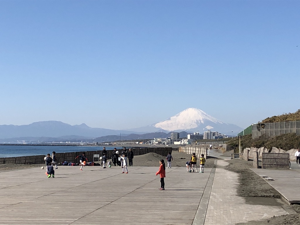
From Kozu I rode on the old Hwy 1 being careful not to get on the Hwy 1 expressway where bikes are prohibited. At Oiso you can go down along the beach and, after crossing the Sagami River, the road becomes Hwy 134. Near Chigasaki there is a paved path that runs along the beach. It is often full of people walking and there is frequently a lot of sand blown in at places but you can’t beat the beautiful view. You can see Mt. Fuji towering behind you and Enoshima Island up ahead.
The road can be pretty busy from Enoshima to Kamakura, though there is a narrow bike lane. Once through Kamakura the traffic lightens up. The next town after Kamakura is Zushi. I like to turn off onto the old road that runs down the Morito Coast in Hayama, the town after Zushi. This is such a pleasant curvy road with so many views of the ocean and Mt Fuji. I recommend stopping at Morito Shrine and checking out the view.
The road rejoins 134 just after Shiosai Park, located next to the Emperor’s retreat center, and continues down the Miura Peninsula. You can check out the Miura rides here.
Shonan Coast Gallery (click on photos)