(click on map to enlarge)

Nikko to Numata
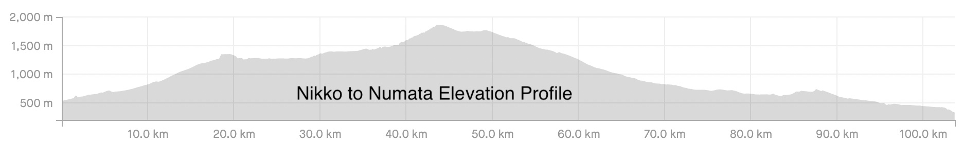
Nikko National Park, in Tochigi Prefecture, is a mountainous area centered around an old volcano, Mt. Nantai. Hwy 120 runs through the park up and over Konsei Pass down into Gunma. The ride I’m describing is a 103 km route along Hwy 120 from Nikko Station to Numata in Gunma Prefecture.
You begin by taking Hwy 122 which runs in front of both JR Nikko and Tobu Nikko train stations as it follows the Nikko River past the iconic Shinkyo Bridge. At 8 km you come to the turnoff to Hwy 120 that begins to climb up to Lake Chuzenji. There is a lot of traffic on this road in the autumn when tourists come to see the autumn foliage. They designed a circular one-way route in order to be able to provide 2 lanes of traffic.
It’s about 20 km up to Lake Chuzenji with an 800-meter elevation gain (the lake is at 1280 m). The road has nice switchbacks that maintain a reasonable grade. There is a short descent down to the lake, which has lots of restaurants and shops on the eastern end. It gets wilder at the west end. The biggest attraction is the spectacular Kegon Falls, located just below the lake’s east end. It’s well worth a stop off to see them.
At about the middle of the lake Hwy 120 heads north up past Ryuzu Falls and into Senjogahara, an area of forest and marshlands. In the autumn they turn a beautiful rust color. The whole area of Nikko becomes a wonderland of color in the fall. I feature an autumn ride in Nikko on the Tochigi page.
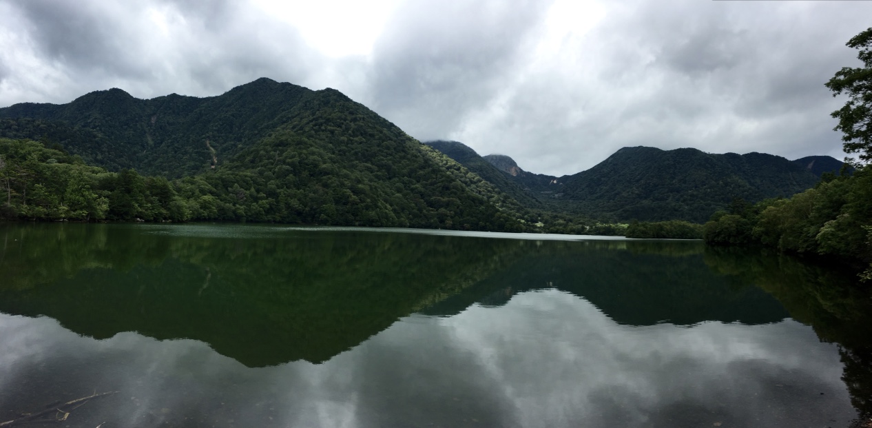
Shortly after leaving Senjogahara you come up to the turn off to Yudaki Falls. I recommend the short trip over to the base of the falls. There is a nice pedestrian bridge right in front of the falls that makes for a good picture. You can also view the falls from the top where they come out of Yuno Lake which has an elevation of 1480 meters. It’s a long, peaceful lake often giving you a nice reflection of the mountains in the lake.
From there the grades get steeper as the road begins to climb toward Konsei Pass. The pass goes through Mount Yusengatake, a majestic craggy peak. The climb is steady and fairly steep. Looking back you get a magnificent view of Mt. Nantai and Lake Chuzenji in the distance.
At 1865m Kosei is the third highest pass in Japan. After the pass you come through a tunnel that empties out into Gunma Prefecture. There are some beautiful emerald-colored lakes on the right side and a ski resort on the left after which you begin a fairly steep descent all the way down into Gunma.
After about 23 km you come to Hwy 421 which runs north into Katashina and the Oze National Park area. About 10 km beyond that is a place you don’t want to miss- Fukiware Falls. They are some picturesque horseshoe shaped falls about 7m high and 30m wide on the Katashina River. The Numata Tourism Board refers to them as the “Oriental Niagara”.
From the falls it’s a 20 km gentle descent down into Numata City. I like the layout of this ride in that you do all of your climbing during the first part (44 km) through the beautiful scenery and then are rewarded with a 60 km descent. It’s definitely a ride to remember.
Nikko to Numata Gallery